Preparation for the Cumbria Way
I have put this page of tips and advice together to hopefully aid novice walkers or walkers new to the route with their preparation for the Cumbria Way. Researching a walk is something I have always enjoyed whether it be looking at the route on a map, reading the guidebook or arranging overnight accommodation.
Please note that this site is no substitute for a map/s covering the route and it is recommended that you go armed on the route with a map, compass and also a decent guidebook to help you along the way. Some of the guidebooks also point out some of the interesting features and places along the Cumbria Way.
Cumbria Way Route Changes
There have been very few changes to the route since its creation in the 1970s and the most up to date information on any route changes or diversions can be found on the Ramblers website. Please check the Ramblers Cumbria Way page as part of your preparation for the Cumbria Way.
I have also listed any relevant changes that I know of and these changes can be found by clicking the following link … Route Changes
How long should I take to walk the Cumbria Way
Although the Cumbria Way can be walked over as many days as you wish there is a problem with the way the route is laid out that makes it difficult to split it into longer or shorter stages. There are sections of the route with next to no accommodation once you start to deviate from the ‘normal’ 5 day trip. This 5 day option is the basis on which I have based this website, indeed, this is the basis I have planned and walked my own Cumbria Way walks.
My personal choice would be that if I had 7 days to walk the Cumbria Way then I would still stick to the 5 day option but give myself an extra day in Coniston and an extra day in Borrowdale or Keswick for some sightseeing and, if you are feeling fit, some extra off route walks. If you are planning shorter or longer Cumbria Way trips durations then browse the Cumbria Way Trip Journals on this website for inspiration.
South to North or North to South on the Cumbria Way
The general consensus seems to be for a south to north trip and this is how the way the Ramblers Association have the walk in their official guide book and to me it is the logical way BUT many people prefer getting the Carlisle to Caldbeck section over and done with first and this means they are walking to the sea at Ulverston. The prevailing wind comes from the west so it will be blowing across the route whichever direction you choose. Likewise the gradients are no easier in either direction and both Carlisle and Ulverston have good links for public transport.

© Darcy Moore
My choice for my 2 previous walks was South to North, not only because I lived only 18 miles from Carlisle at the time but more importantly it just felt the right way to walk the route. Having said that, the next time I walk the route it will be North to South so I can enjoy the different views (and get that cycleway out of the way!)
Getting to and from the Cumbria Way
Public Transport
Both ends of the Cumbria Way are well served by public transport. Carlisle is a very busy station on the West Coast Mainline with many connections, whether it be train or bus, across the country. It also links with Ulverston via the scenic Cumbria Coastal Line. Ulverston station is quieter and sits on the Furness Line. There are services to Lancaster and Preston to join the West Coast Mainline as well as Manchester. For more info visit www.thetrainline.com
The route is, on the whole, well covered by local buses and more details on local bus routes can be found on Cumbria County Council’s website
Car Parking
There is an option of parking your car right at the start of the route at The Gill in Ulverston. You can either purchase a 3 or 7 day pass and further details can be found here – Cumbria Way parking at Ulverston. I am currently unaware of a similar option in Carlisle but if you wish to walk the route from North to South then you could always park at Ulverston and catch the train to Carlisle?
Accommodation along the Cumbria Way
This is one aspect of your preparation for the Cumbria Way that you should do as early as possible. If you are staying in B&B’s, Camping barns, YH’s etc then you should always pre-book your accommodation especially in the very busy summer months. Be aware that in some areas such as Langdale and Keswick there is a shortage of one night only stays with most establishments asking for a minimum 2 night stay.
There are some places along the route, Caldbeck is a good example, which have a limited number of places to stay and therefore beds fill up quickly. If you are struggling then one tip is to try somewhere slightly further afield and ask if they are willing to pick you up and drop you off the following morning. I have done this twice in the past and have never being charged extra for it.
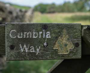
Signage and Waymarking on the Cumbria Way

© Darcy Moore
As a whole the Cumbria Way is pretty well trodden on the ground and this, along with a selection of small, official way-marker signs marked like the one shown, does help to point you in the right direction. Having said that some of the signs are quite old and faded and can be found fingerposts, gates or even stiles.
Remember signage can be sporadic on sections of the route, especially between Keswick and Caldbeck, so pay attention to your map and guidebook if you are in any doubt.
There are plenty of traditional wooden sign posts marking the route of the Cumbria Way and other footpaths as you would normally find in the countryside. On top of this there are quite a few of ‘unofficial’ signs pointing the way, mostly made from paint on slabs of slate or large rocks.
However, I would always recommend carrying a map & compass as well as the ability to use them. a guide book for extra guidance – details of many of the available publications are listed on the Maps and Guidebooks page of this website.

© Darcy Moore
When to walk the Cumbria Way
As we all know, Cumbria and the Lake District can get wet, indeed the wettest inhabited place in England lies but a mere 4 km from the Cumbria Way at Seathwaite. On the upside Cumbria also has a surprisingly large number of glorious fell-walking days. Alas I can’t guarantee when any of these are going to happen and all I can do is say ‘be prepared for anything’ It is always advisable to check the weather before you set off for each days walking. My go-to weather site is the Mountain Weather Information Service but also check out www.lakedistrictweatherline.co.uk.
The winter months bring the danger of snow and ice along with very short daylight hours. Spring and Autumn often bring periods of settled weather whereas Summer will be very busy with an accompanying hike in the cost of accommodation or indeed availability of accommodation. In short, April through to October seems to be the general ‘walking season’ on the Cumbria Way but, as mentioned, keep an eye out for the the weather and go prepared.
Carrying enough food and drink for the day
Although the Cumbria Way follows, in the main, a low level route you should remember that some stages have next to nothing in the way of shops or cafes for quite a lot, or all, of the day. Indeed, Day 4 will see you leave Keswick for Caldbeck with no refreshment available for the whole of the day whilst Day 5, Caldbeck to Carlisle, is pretty similar. Day 1, Ulverston to Coniston, is also bereft of refreshment along most of the days route.
I have placed details of cafes/shops/bars along the way on each stage on the Route Info section of this website so that you will know when you need to fill up with both food and drinks before you leave. Remember that you are walking a long way each day and the need to refresh with both liquids and food is vitally important. Consider taking advantage of the Accommodation Providers who offer a packed lunch and carry a couple of large water bottles so you can fill up with water before you leave your accommodation.
Remember you will need to carry everything in your rucksack
Unless you are using a Baggage Transfer service then you will have to carry all of your clothes and belongings on your back. I will assume that a; you have a large enough rucksack – minimum 35 litres – to hold all of your gear and b; that you are used to carrying a heavy rucksack for long periods of time. Do not underestimate the effort that it takes out of you to carry a heavy rucksack for 6 or 7 hours a day for 5 days.
Remember also, that due to lack of shops, cafes etc on some stretches of the Cumbria Way, you will need to carry enough food and water to see you through the day. Experienced long distance walkers will have all of this down to a fine art but for folks new to long distance hikes I have listed the bare minimum that I will take with me on a 5 day walk. This is a very basic list to see me through but you may wish to add other items such as a camera, notebook and pen to record your trip, your own towel etc.
Going through your own requirements will entail careful planning and restraint in not taking the kitchen sink! Practice packing your rucksack and get used to carrying it by walking with it before the trip a few times. Remember to take enough waterproof sacks (or bin liners) to keep your carefully selected gear dry.
My basic checklist
Waterproof outer layers
Boots & 5 pairs of socks
2 pairs of walking trousers
1 pair of shorts
5 pairs of underpants
4 wicking T-Shirts
Warm fleece or soft shell
Gloves & Hat
Guide-book & map
Compass
2 large water bottles
Smartphone & charger
Cash and debit card
Sandals for the evenings
Toiletries
Dry Sacs to keep it all dry
And for emergencies:
Foil blanket, Head torch & spare batteries, Whistle, Flapjack
Baggage Transfer and Organised Holidays
There are companies out there who offer a baggage transfer service transporting your stuff between your chosen accommodation leaving you free to enjoy the route whilst traveling light. Other companies offer organised holidays, either guided or self guided. They will book your accommodation, transport your luggage between accommodation and provide advice, maps, guidebooks etc. If you are interested in any of the services offered I have compiled a list of companies for you to contact. More details at Baggage Transfer/Holidays
© Darcy Moore
All weather clothing and Footwear
Whatever the weather always carry adequate foul weather clothing with you as this is Lakeland and whilst you may be in bright sunshine in one valley the next one along could very well be bucketing it down. Before you set off ensure that your waterproof jacket and over-trousers are in good condition and will actually keep the rain out.
Wear good quality, lightweight and preferably waterproof boots and make sure they are well worn in before the big walk. It is also worth pointing out that socks are one of walkers best friends so invest in some decent ones.
Cumbria Way Guide Books and Maps
There are many guide books dedicated to The Cumbria Way and although quite a few are out of print these can still be purchased online at decent prices. The route itself has not changed much since the 1970’s and most likely will not change much in the next 30 years.
I have copies of most of the guide books but in all honesty the one that have I taken with me the most was The Cumbria Way by John Trevelyan which is now pretty tattered.
The standard of mapping in most guidebooks is pretty low so I would definitely recommend that you take a decent map with you to complement the guidebook. Again, I have listed some of these Cumbria Way guidebooks and maps for you to choose your own.
Fit to walk the Cumbria Way
The Cumbria Way is a generally low level walk with only 2 major climbs along the way. The first is the unavoidable ascent of Stake Pass at the start of Day 3 and then on Day 4 the long slow climb up to High Pike – the only Wainwright fell on the route. The ascent of High Pike can be avoided but I have done both options and unless it is cloudy on the tops then I would always opt for the High Pike route.
There are, of course, other ups and downs along the route but nothing to unduly worry you. Fitness wise a fell walk once a fortnight is not going to be enough to see you through 5 days of walking and you will need to build up towards what is an enjoyable but relatively serious undertaking.
As a general rule of thumb once you can manage a minimum of two consecutive, long days of fell walking then you are pretty much ready to tackle the route. If you haven’t walked any great distance before then you will obviously need to do some serious training before you start. The golden rule is start off gently and build up and if you are in any doubt about your fitness then check with your doctor.